Understanding The Urgency For Indoor Maps
Today, most people expect that 9-1-1 call centers can pinpoint their exact location during emergency calls, even inside of buildings. But you do not have to look far to find high profile cases where challenges locating 9-1-1 callers indoors have contributed to increased emergency response times, and even tragic outcomes.
While new regulations, standards, and technologies are emerging that can provide raw position measurements for wireless 9-1-1 callers indoors, all too often this information is not actionable, and provides little more than a blue dot on an otherwise blank whiteboard for emergency responders. The advancements in indoor positioning for 9-1-1 create an opportunity to reduce emergency response times inside large and complex indoor environments, but this opportunity will go unrealized without details and context about indoor spaces that can be combined with raw positioning measurements. As a result, there is an urgent need for indoor maps for 9-1-1 and public safety emergency responders.
The Federal Communications Commission (FCC) has made locating 9-1-1 callers indoors a priority by enacting new rules that require wireless carriers to calculate indoor positions, including in three dimensions, for 9-1-1 calls from mobiles phones.
One of the FCC commissioners, Geoffrey Starks commented:
“It is essential that help arrives in the right place and on the right floor. Only floor level accuracy will give first responders the right tools to go to the right floor, the first time, every time. We need a plan to get there and that plan has to get it done as quickly as possible.”
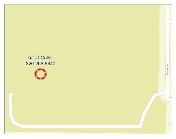
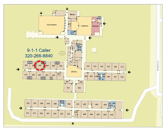
The following examples depict an indoor caller location with and without indoor maps.
While the FCC rules provide 9-1-1 positioning requirements for wireless carriers, providing local GIS mapping requirements is out of scope. The original FCC ruling documents note that 9-1-1 call centers will need to implement technology such as 9-1-1 mapping applications that are capable of making the new caller position information actionable.
With over 125 million buildings in the United States, it is important to note that responsibility goes beyond PSAPs and 9-1-1 authorities, and extends across state and local government, vendors and systems / service providers, and the community at large. We all play a role in making the indoor environments in which we work and do business safer during 9-1-1 calls.
As a result, 9-1-1 authorities need to begin planning for indoor mapping. Such planning includes elements such as:
- Educating key stakeholders across the public safety enterprise on the challenges associated with indoor 9-1-1 caller location,
- Promoting the impact of indoor maps for reducing emergency response times, protecting more property, and saving more lives,
- Discussing options for adding indoor maps with your 9-1-1 PSAP mapping application provider (it is important that 9-1-1 and CAD mapping applications support indoor positioning and indoor maps, as well as floor aware displays that include floor selection and other tools for easily accessing and toggling indoor maps),
- And identifying opportunities for public private partnerships where public and community calls to action can help bring in indoor maps for critical building assets and locations in the community.
A motto for 9-1-1 is that seconds matter. All too often, even in this day and age, challenges locating 9-1-1 callers have contributed to negative emergency response outcomes. Emerging technology is providing better and better caller position measurements, but now it is up to public safety agencies, vendors and communities to work together to establish urgency around incorporating potentially life-saving indoor mapping into public safety and 9-1-1 operations.

This map lacks indoor mapping and provides little additional context for emergency responders.
In contrast, this map provides detailed indoor mapping information, enabling emergency responders to visualize where in the building the caller is located, as well as the best building entrances to access the scene faster.


