Key Factors for Creating, Developing and Deploying GIS data for Indoor Maps
Every second counts when it comes to public safety emergency response.
And yet, building interiors have been a black hole of data for telecommunicators: It’s nearly impossible to pinpoint the exact location of a caller and there’s little visibility into the interior of the building, such as doors, stairways and exits. This lack of information threatens responders’ ability to move quickly and safely toward a situation.
In June 2021, the FCC instructed the three major U.S. mobile carriers to begin providing z-axis data to emergency service centers. While this is a step in the right direction, X, Y and Z data doesn’t provide a complete picture for indoor mapping scenarios. Telecommunicators accessing this location data are still faced with important questions, such as:
How can first responders access that location?
What’s the fastest and safest way to get there?
Are there hazards in the vicinity, such as flammable materials or chemicals?
Are there life-saving assets nearby, such as AEDs or fire extinguishers?
The benefits of combining 9-1-1 positioning with indoor maps
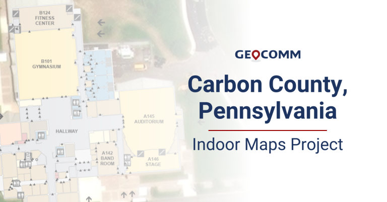
Public Safety Location Intelligence® answers the questions above by combining 9-1-1 call data with detailed, easy-to-read indoor maps that display:
Building footprints with exterior entrances clearly defined
Interior rooms identified by name/number, and color coded by type
Locations of elevators, escalators, stairs and interior doors
Relevant point locations, such as Automated External Defibrillator (AED), fire extinguishers, fire risers and security cameras
Indoor maps give telecommunicators and first responders optimal situational awareness, helping improve response times and save lives. “Indoor maps aren’t big and scary,” said Keri Brennan, GeoComm Product Manager – Public Safety GIS Content and Services. “It’s simply another dataset within your GIS arsenal. Think of developing and adding it in as if it were any other beneficial GIS dataset.”
How to set up indoor maps
GeoComm Indoor Maps is a service offering aimed at supporting telecommunicators, law enforcement, fire and medical responders. These are accessible in GeoComm Maps or other public safety mapping applications.
The first and most important step when building out indoor maps is securing strong community relationships in order to access building-level data in the form of building plans. This requires educating and engaging stakeholders – sheriffs, EMS, fire, politicians, city councils and school leaders, etc. – on how indoor mapping data impacts emergency services for the better.
See how this District Implemented Indoor Mapping Program for Area Schools
Content with the right context
Indoor maps of key buildings improve situational awareness and reduce response times. An address point on a map with no structure information doesn’t provide helpful context to call-takers and first responders. GeoComm Indoor Maps provides the next level of precise Public Safety Locational Intelligence.
After gathering the necessary data, we will work with you to convert it into actionable GIS data quickly and easily. The data is hosted in our secure content library, accessible to public safety agencies through secure access via GeoComm products or third-party partner applications. Data ownership remains in your hands.
Our patented processes leverage machine learning and artificial intelligence for fast, efficient data creation. The information is geo-referenced to base data and undergoes rigorous QC analysis. Our QC analysis processes use both machine learning and the best quality judge: the human eye.
In the end, your data will be delivered through secure hosted services. The data can also be delivered in a mobile map package or in the Esri ArcGIS Indoors format.


