Home > Press Releases > City of Austin, Texas Completes Project Aimed at Improving GIS Data Provided in Their CAD System
FacebookLinkedInXPinterestEmail
Dark Mode

City of Austin, Texas Completes Project Aimed at Improving GIS Data Provided in Their CAD System

“We sincerely appreciate all of GeoComm’s hard work for this public safety project.  The collaboration and professionalism everyone demonstrated throughout this project was wonderful.  We will certainly reach out to GeoComm if we need future GIS assistance,” said John Regalado – Public Safety IT Manager, City of Austin, Texas.

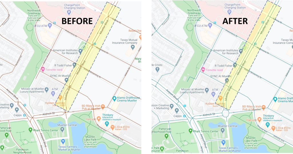
The City of Austin, Texas was recently experiencing some difficulties with spoken vehicle routing directions provided in their Computer Aided Dispatch (CAD) mobile units. Their main objective was to correct the roads segments on dual carriageway streets with a physical barrier for a median, which caused the segment to come together in a “pinched” fashion (see BEFORE pic). They requested GeoComm assist them with the project by completing spatial and attribute updates to their Road Centerline Layer to straighten the road segments into more “ladder-like” parallel lines (see AFTER pic). This resulted in improving the vehicle routing directions provided by CAD system to the mobile units.
April 21, 2020

GIS Resources

GeoComm Welcomes New Chief Product and Technology Officer

GeoComm, a trusted leader in GIS-based indoor and outdoor map data management solutions, is proud to announce the appointment of Daniel Stonecipher as its new Chief Product and Technology Officer (CPTO) and key member of the executive leadership team.

ZeroEyes and GeoComm Partner to Enhance Iowa School Safety with Advanced AI Gun Detection and Intelligent Mapping

ZeroEyes, the creators of the only AI-based gun detection video analytics platform that holds the US Department of Homeland Security Safety Act Designation, and GeoComm, the provider of locally authoritative indoor and outdoor Geographic Information Systems (GIS), today announced a technology integration partnership to enhance emergency response and school safety. This collaboration merges ZeroEyes' AI gun detection and situational awareness software with GeoComm's comprehensive indoor mapping solutions to provide real-time, actionable intelligence to any Iowa K-12 schools.

New Digital Mapping System Set to Improve Security at Florence Schools

Florence 1 Schools continues to lead the way in school safety and security efforts, implementing a new digital, interactive mapping program that provides first responders with critical information during emergency calls, according to a news release.