Carbon County 9-1-1 Indoor Maps Project
Written by Justin E. Markell, Assistant 9-1-1 Manager – Carbon County 9-1-1
CARBON COUNTY, PA – Since 9/11, it has become apparent that first responders and 9-1-1 Dispatchers need as much information about the buildings in their response area as they can possibly get. All too often in the United States, we have watched scenes of an active shooter play out on television. The lessons learned from these critical incidents tell us that it is crucial for first responders to know what awaits them inside buildings before they enter in order to save time and ultimately save lives in these incidents. Carbon County is home to a population of 65,000 residents, with tourism bringing an additional 285,000+ visitors to the county each year.
In 2018, it became apparent to the Carbon County Communications Center during a software transition that floor plans for buildings in Carbon County would be a valuable and vital piece of information for our Dispatchers. The problem we encountered though was how to get indoor maps into our GIS data in the most cost-effective manner and how to make them easily available to our dispatchers. The Carbon County Communications Center partnered with GeoComm to complete this project. The project started by uploading all the floor plans we acquired to GeoComm where their team digitized the plans into actionable GIS data layers. The GIS data layers were sent back to us completed on a monthly basis for integration into our GIS data.
“Carbon County doesn’t have the financial resources that some of the larger counties may have available to them. Therefore, we need to find ways to continue to be on the cutting edge while doing it in the most financially responsible manner,” said Justin E. Markell, Assistant 911 Manager.
As an added benefit, our indoor maps are also available in RapidSOS Portal. GeoComm had already established a strategic partnership with RapidSOS whereby the indoor maps provided by GeoComm would be embedded in RapidSOS Portal, empowering Carbon County Communications Center with any easy way to view and utilize the building floor plans and indoor maps.
A Solution is Found
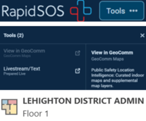
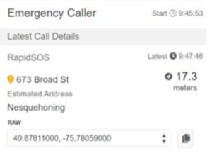
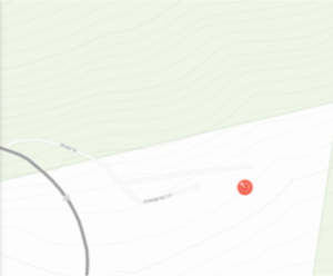
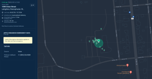
What did that mean for the Carbon County Communications Center? Well, there would be no additional steps for 9-1-1 Dispatchers to obtain vital location information on where a caller/emergency may be inside a building. Dispatchers were already referencing RapidSOS Portal during a 9-1-1 call and could simply open the indoor maps which zooms the map to where the call is located and if it is in a building with an indoor floor plan already submitted, the call will display where the caller is located inside the building. This occurred with Carbon County Communications Center incurring no additional financial costs.
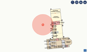
[The above illustration is an example of a 9-1-1 call plotting on the property of the Lehighton Area School District – Administration Building]
“Due to our 9-1-1 Dispatchers already using RapidSOS Portal on a daily basis there was no need to re-invent the wheel so-to-speak we felt it was best for our agency to simply have our dispatchers utilize the indoor maps information from GeoComm via RapidSOS Portal,” said Justin E. Markell, Assistant 911 Manager.


