Geographic Information Systems Insights
Martin County Sheriff’s Office Launches Project to Enhance 9-1-1 Services
MARTIN COUNTY, Fla. (CBS12) — A project is underway to improve 911 emergency response services in Martin County. The Martin County Sheriff’s Office (MCSO) says that from Wednesday to February 3, deputies, including field technicians from the firm GeoComm, will visit certain Martin County homes to confirm addresses and street names. A map provided by...

ZeroEyes and GeoComm Partner to Enhance Iowa School Safety with Advanced AI Gun Detection and Intelligent Mapping
ZeroEyes, the creators of the only AI-based gun detection video analytics platform that holds the US Department of Homeland Security Safety Act Designation, and GeoComm, the provider of locally authoritative indoor and outdoor Geographic Information Systems (GIS), today announced a technology integration partnership to enhance emergency response and school safety. This collaboration merges ZeroEyes' AI gun detection and situational awareness software with GeoComm's comprehensive indoor mapping solutions to provide real-time, actionable intelligence to any Iowa K-12 schools.

Unlocking the Power of Map Data Manager: Enhancing School Safety & Indoor Safety
An indoor map delivers the next level of precise location information via a highly organized visualization of all the essential elements in a building. Bringing your building to life with a detailed map and into the hands of those who need it is a critical first step to unlocking seamless navigation and enhanced accessibility!

New Digital Mapping System Set to Improve Security at Florence Schools
Florence 1 Schools continues to lead the way in school safety and security efforts, implementing a new digital, interactive mapping program that provides first responders with critical information during emergency calls, according to a news release.

GeoComm Announces Integration of Indoor Maps into CrisisGo’s Safety iResponse System to Enhance School Safety
GeoComm, a leader in providing locally authoritative indoor and outdoor Geographic Information Systems, and CrisisGo, a leading provider of comprehensive safety communication systems, are proud to announce the integration of GeoComm's advanced indoor mapping technology into CrisisGo's Safety iResponse platform.
San Felipe Del Rio CISD Integrates GeoComm to Elevate School Safety with Advanced Digital Mapping
GeoComm, a leader in school safety solutions, is proud to announce that San Felipe Del Rio Consolidated Independent School District (CISD) has become the latest district to implement GeoComm’s advanced indoor mapping technology. This opportunity highlights the district’s unwavering commitment to enhancing the safety of its students, staff and community.

Intrado and GeoComm Partner to Enhance Safety in Schools and Enterprise Buildings
Intrado Life & Safety, a global leader in public safety solutions, today announced a partnership with GeoComm, a leading provider of Geographical Information Systems (GIS) data.

GeoComm and the National Association of School and Campus Police Chiefs Announce Partnership in Support of School Safety and Security
GeoComm, creator and deliverer of locally authoritative indoor and outdoor GIS for mission critical applications, and the National Association of School and Campus Police Chiefs (NASCPC), an invaluable non-profit dedicated to being a powerful ally for those responsible for keeping our children and schools safe, are excited to collectively work to provide professional training, resources and collaboration for all parties involved in school safety and security.

GeoComm Receives Esri’s GIS for Good Award at Esri Partner Conference for Exceptional Achievement
GeoComm received Esri’s GIS is for Good award at the 2024 Esri Partner Conference (EPC) held March 10–11, 2024 in Palm Springs, California. This award was presented to GeoComm for compelling use of Esri technology to make an impact on current issues around the world, such as sustainable development, climate change, diversity and social equity, and humanitarian aid.
GeoComm and ELi Technology Announce Partnership aimed at Enhancing School Safety with new “ATLS Location Service”
GeoComm, creator, and deliverer of locally authoritative indoor and outdoor GIS for mission-critical applications, and ELi Technology Inc. (ELi), provider of the “verified dispatchable location methodology”, known as Emergency Mobile Location (EML), are excited to announce a partnership offering a location service, known as ATLS, driven to enhance school safety.
GeoComm and RapidSOS Empower Emergency Communications Centers with Indoor Maps Creating Enhanced Emergency Response Location Information
GeoComm, provider of Public Safety Location Intelligence®, and RapidSOS, creator of the world’s first intelligent safety platform, are excited to announce the integration of GeoComm Indoor Maps into RapidSOS premium.
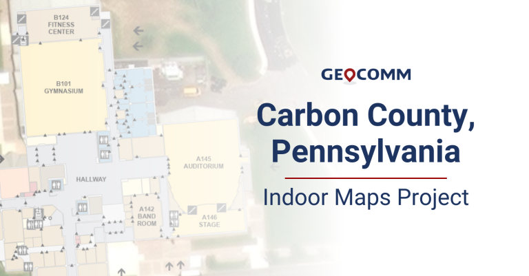
Carbon County 9-1-1 Indoor Maps Project
The Carbon County Pennsylvania Communications Center recently partnered with GeoComm to create GIS-based indoor maps for buildings throughout their county. These indoor maps would be valuable and vital pieces of information for their dispatchers and first responders to aid in improving situational awareness and decreasing response times. Carbon County Communications Center dispatchers access their indoor maps in RapidSOS Portal, provided by GeoComm partner RapidSOS.