Geographic Information Systems Insights
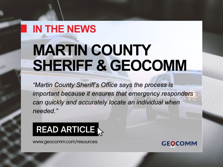
Martin County Sheriff’s Office Launches Project to Enhance 9-1-1 Services
MARTIN COUNTY, Fla. (CBS12) — A project is underway to improve 911 emergency response services in Martin County. The Martin County Sheriff’s Office (MCSO) says that from Wednesday to February 3, deputies, including field technicians from the firm GeoComm, will visit certain Martin County homes to confirm addresses and street names. A map provided by...

ZeroEyes and GeoComm Partner to Enhance Iowa School Safety with Advanced AI Gun Detection and Intelligent Mapping
ZeroEyes, the creators of the only AI-based gun detection video analytics platform that holds the US Department of Homeland Security Safety Act Designation, and GeoComm, the provider of locally authoritative indoor and outdoor Geographic Information Systems (GIS), today announced a technology integration partnership to enhance emergency response and school safety. This collaboration merges ZeroEyes' AI gun detection and situational awareness software with GeoComm's comprehensive indoor mapping solutions to provide real-time, actionable intelligence to any Iowa K-12 schools.

Unlocking the Power of Map Data Manager: Enhancing School Safety & Indoor Safety
An indoor map delivers the next level of precise location information via a highly organized visualization of all the essential elements in a building. Bringing your building to life with a detailed map and into the hands of those who need it is a critical first step to unlocking seamless navigation and enhanced accessibility!

Empower 9-1-1 and emergency response with game changing Public Safety Grade GIS data
NG9-1-1 is a game changer for the 9-1-1 community because it utilizes Geographic Information Systems (GIS) technology to deliver every 9-1-1 call – mobile, VoIP, and landline alike – to 9-1-1 communication centers.
Powering your Public Safety Systems with Improved GIS Data
When answering a 9-1-1 call, access to accurate and up–to–date map data is essential because seconds count. Fortunately, achieving the necessary quality map data needed for 9-1-1 can happen with just a few steps. Your steps involve assessing, improving, maintaining, and sharing your Geographic Information System (GIS) data to fulfill its mission critical role in current and future 9-1-1 systems.
GIS Data Assessment – Laying a Foundation for Success
How accurate is the public safety map data in your community? Does your call taker, dispatcher, and first responder have the necessary data during those critical seconds? These are important questions GIS and 9-1-1 teams need to answer. Learn how we can help you lay a foundation for success through a GIS data assessment.

2022 Texas DIR Contract and Pricing
GeoComm, a leading provider of geographic information and communication systems, has been awarded a Texas Department of Information Resources (DIR) contract DIR-CPO-4499 for GeoComm’s public safety software.
The Next Frontier of 9-1-1 Mapping – Indoors
For many years the focus for Public Safety Grade GIS has been on site structure address points, road centerlines, service boundaries, and PSAP boundaries for routing 9-1-1 calls in a NG 9-1-1 systems. As we progress towards full NG9-1-1 implementations, having indoor context about the location of calls within indoor spaces will be critical for telecommunicators and first on scene responders.
Customer Profile: Rio Grande Council of Government (RGCOG)
Rio Grande Council of Government (RGCOG) went live with GeoComm Maps as part of a cloud-native call-handling implementation by Carbyne. The system went live in February of this year and provides RGCOG, a regional entity that manages 9-1-1 for five of the most rural counties in the United States, with the latest technology.

Key Factors for Creating, Developing and Deploying GIS data for Indoor Maps
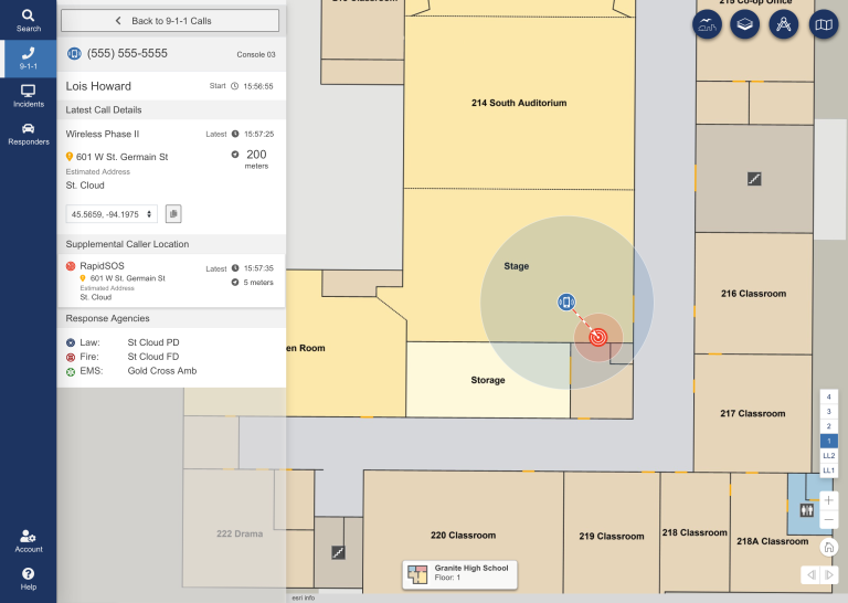
Every second counts when it comes to public safety emergency response. Public Safety Location Intelligence® from GeoComm combines 9-1-1 call data with detailed, easy-to-read indoor maps, providing telecommunicators and first responders optimal situational awareness, helping improve response times and save lives.

GeoComm Perspective: Understanding the Urgency for Indoor Maps
The 9-1-1 industry is at a unique point in time. Technology advancements allow 9-1-1 caller location, X,Y,Z to now be delivered to the PSAP. In order to make this information actionable, indoor maps are needed. Are you interested in learning more about the value of indoor maps and discussing how to start your indoor mapping program is so attend our webinar Getting The Most Out Of Your Public Safety GIS Data Including Indoor Maps on Wednesday, January 26 at 1:00 p.m. Central Time.
Public Safety Grade GIS Data is Critical for Public Safety Emergency Response Systems
GIS data plays a key role accurate emergency response it important for 9-1-1 to implement Public Safety Grade GIS data. These mission critical life safety systems and applications rely on GIS data to drive emergency response - helping to save lives and protect property. This GIS data must be highly accurate, highly secure, highly available, up-to-date, and commonly accessible to all mission critical life safety applications across 9-1-1 and public safety organizations.