Why Critical Incident Mapping is Essential for Emergency Response
Emergencies unfold in seconds, and every moment matters. Whether it’s a school lockdown, active threat, medical emergency, or natural disaster, first responders need immediate access to accurate, real-time mapping data to make split-second decisions. This is where Critical Incident Mapping (CIM) plays a life-saving role.
The Growing Need for Critical Incident Mapping
As schools, businesses, and municipalities invest in safety preparedness, the demand for Critical Incident Mapping is growing. Many school districts, for example, are now eligible for state grants that fund advanced GIS-based mapping solutions—reinforcing the importance of real-time, interactive digital maps in emergency response.
What is Critical Incident Mapping?
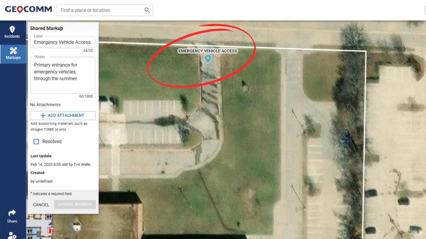
Critical Incident Mapping refers to digitally enhanced, GIS-powered maps that provide first responders, law enforcement, and emergency teams with a detailed, real-time view of a location.
Unlike traditional paper floor plans, Critical Incident Mapping (CIM):
- Provides interactive, digital access to school buildings, campuses, and large facilities
- Pinpoints critical assets (e.g., emergency exits, defibrillators, cameras, alarms, first aid stations)
- Displays real-time updates during incidents
- Improves communication between 911 dispatch, local law enforcement, and school administrators
How Critical Incident Mapping Works
CIM solutions, such as GeoComm’s school safety mapping technology, leverage GIS (Geographic Information Systems) to convert complex floor plans into interactive, navigable emergency response tools.
- 3D Building Overlays – Provides detailed multi-floor navigation for responders.
- High-Risk Zones Identified – Flags entry/exit points, potential threat locations, and evacuation paths.
- Live Data Integration – Syncs with security cameras, sensors, and alarms to enhance situational awareness.
- Mobile Access – Ensures first responders can instantly pull up maps via smartphones, tablets, or in-car systems.
Why Critical Incident Mapping is Crucial for School Safety
1. Faster Emergency Response Times
When an incident occurs, minutes—even seconds—can be the difference between life and death. Traditional paper maps are outdated, slow, and inefficient. Digital CIM solutions empower responders by providing:
✔ Turn-by-turn navigation inside buildings
✔ Quick identification of shelter areas and safe zones
✔ Real-time tracking of law enforcement movement
2. Enhanced Situational Awareness
During high-stress situations, responders need full visibility of their environment. CIM:
- Reduces confusion by offering a real-time layout of buildings
- Integrates with live security feeds for a complete 360-degree awareness
- Pre-identifies key access points for faster response entry
3. Meets Compliance & Grant Requirements
Many school districts are now required to enhance emergency preparedness to qualify for safety grants. CIM:
📌 Fulfills State grant criteria for school safety funding
📌 Aligns with state and federal mandates for digital security mapping
📌 Improves coordination with emergency personnel before, during, and after incidents
The Future of Emergency Response is Digital
Traditional static maps are obsolete in today’s fast-moving emergency response landscape. With advancements in AI, GIS, and cloud technology, CIM is evolving rapidly to include:
- AI-Powered Predictive Analysis – Identifies potential threats before they happen
- Automated Data Syncing – Updates maps instantly when facilities change
- Augmented Reality (AR) Integration – Allows responders to visualize routes in real-time
GeoComm is at the forefront of Critical Incident Mapping technology, ensuring schools, businesses, and public spaces are prepared for any emergency.
How to Implement Critical Incident Mapping in Your School
✔ Assess Current Safety Infrastructure – Identify gaps in emergency preparedness.
✔ Select a GIS-Based CIM Solution – Partner with GeoComm to implement an interactive mapping platform.
✔ Train Staff & First Responders – Ensure teams understand how to access and utilize CIM.
✔ Apply for Safety Grants – Leverage state funding (such as school safety grants; MN HF 3805, TEA SAFE CYCLE 1 & 2 ) to support your mapping initiative.
Frequently Asked Questions (FAQ)
What makes Critical Incident Mapping different from traditional maps?
Traditional maps are static and quickly become outdated. CIM solutions offer interactive, real-time, digital access to building layouts, security features, and emergency assets.
Can Critical Incident Mapping integrate with security cameras?
Yes! Advanced CIM solutions like GeoComm’s safety mapping integrate with live security feeds, access controls, and 911 dispatch systems.
Do schools need Critical Incident Mapping to receive safety grants?
It depends, however most states prioritize funding for schools implementing digital mapping technology to enhance emergency response.
Learn more about GeoComm critical incident mapping