GIS-powered Critical Incident Mapping Helps Minnesota First Responders Reach a Medical Emergency Victim in Seconds
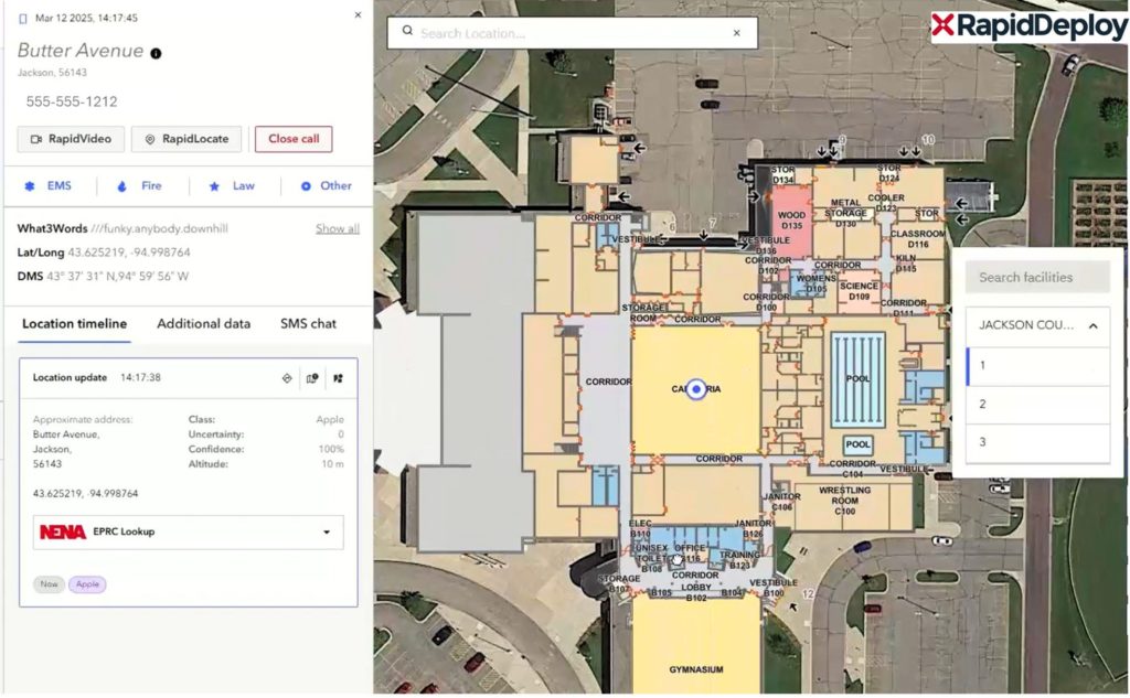
JACKSON COUNTY, Minn., March 24, 2025 /PRNewswire/ — A life-threatening medical emergency at a Jackson County high school on October 3rd, 2024 put First Responders to the test when a student suffered a medical complication in the cafeteria. Thanks to the swift response of the Jackson County Sheriff’s Department and GeoComm’s GIS-powered critical incident mapping technology, emergency personnel pinpointed the exact location within seconds, accessed the school through the nearest entrance, and provided life-saving aid without delay.
Faster Response with GIS-Based Indoor Maps
Unlike static PDF floor plans, which can be outdated and difficult to interpret, GeoComm’s real-time, GIS-driven indoor mapping solution—integrated into RapidDeploy’s Radius Mapping platform—enabled dispatchers and first responders to identify the precise room and nearest entry point instantly.
“When the 911 alert came in, we could see exactly where in the cafeteria the student was located,” said Sheriff Shawn Haken, Jackson County, MN.
“This allowed us to take the fastest route, park the ambulance right outside the correct door, and get inside within moments. The GeoComm indoor map was extremely precise—down to the table next to the emergency call. That level of accuracy is a game-changer for emergency response.”
Minnesota Schools Can Now Implement This Life-Saving Technology
Recognizing the critical role of GIS-based school safety mapping, the Minnesota Legislature allocated funding to help schools implement this technology. Schools across the state now have the opportunity to upgrade their emergency response capabilities with the same real-time mapping solution that helped first responders in Jackson County.
“This incident underscores why static floor plans specifically PDFs, CAD or GeoTIFFs are no longer enough,” said Bill McCullough, VP of Sales and Marketing at GeoComm.
“GIS-based critical incident mapping ensures first responders never waste time figuring out where to go in an emergency. Now, with state funding soon available in Minnesota, schools can work directly with GeoComm to take proactive steps to enhance safety and emergency preparedness.”
- Watch how GIS data empowers critical incident mapping in 60 seconds
- Learn more about GeoComm School Safety
About GeoComm
For over 30 years, GeoComm has been the trusted leader in public safety, delivering advanced location intelligence to help protect over 100 million people nationwide. Our GIS based solutions empower 9-1-1 and emergency response teams with accurate, real-time location data ensuring the right information is delivered to the right people at the right time. From local to statewide and military agencies GeoComm is the trusted source for enhancing public safety. Learn more at www.geocomm.com/school-safety
Read the full article on PRNewswire