Southwest Minnesota: Digital Geographic Information System Mapping & 9-1-1 Emergency Response
Overview
In 2023, the Southwest Minnesota Emergency Communications Board (SWECB) partnered with GeoComm to launch an indoor mapping pilot project. This digital geographic information system mapping initiative transformed critical infrastructure buildings into GIS-powered indoor maps, providing first responders with precise, real-time location intelligence and the school mapping data needed to ensure effective emergency response.
The Challenge: Why Accurate Indoor Maps Matter
First responders often face delays due to limited indoor navigation within critical buildings. To improve emergency response, the region needed accurate, real-time school mapping data to help telecommunicators and first responders pinpoint exact locations during emergencies.
The Solution: Digital Geographic Information System Mapping
- Collect & digitize existing building floor plans
- Convert campus data into comprehensive school mapping data powered by indoor GIS tailored for public safety applications
- Seamlessly integrate maps into 9-1-1 and emergency response systems
How We Collected & Converted GIS Data for First Responders
Precise indoor maps that improve navigation & situational awareness during emergencies.
Video: Emergency responders knew exactly where to go, thanks to GeoComm’s indoor map integration with RapidDeploy Radius Mapping. The 9-1-1 alert instantly pinpointed the student’s exact location on the digital map, guiding responders to the nearest entrance.
Real-World Impact: Precise Indoor Navigation
Safer Schools. Smarter Operations.
In 2024, a student suffered a medical emergency in a newly mapped school cafeteria. Thanks to GeoComm’s indoor mapping solution, the incident location was instantly displayed on the dispatcher’s screen, guiding first responders to the exact spot.
“The incident popped up right on top of the newly mapped building in the correct location. The GeoComm indoor map was very helpful for our 9-1-1 dispatcher and deputies who were responding.“
-Sheriff Shawn Haken, Jackson County, MN
Project Scope & Results
- 350M+ square footage mapped
- 113 buildings
- 80 schools and hospitals
- 17 government facilities and warehouses
- 16 additional buildings
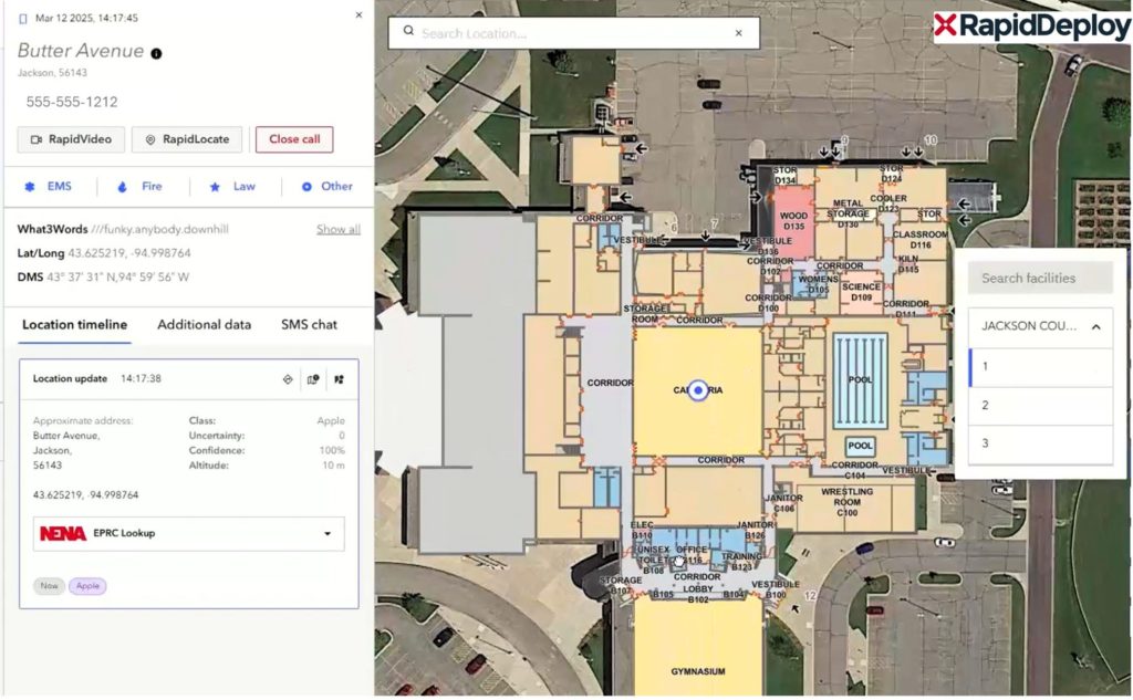
Jackson County Sheriff’s Department utilized GeoComm Indoor Maps in RapidDeploy Radius to accurately locate the origin of a medical emergency 9-1-1 call. This precise mapping enabled responders to identify the nearest entrance and efficiently navigate to the scene, ensuring a swift and effective response.
Next Steps
GeoComm’s school mapping data and digital geographic information system mapping empowers emergency responders with the intelligence they need—when seconds matter most. Want to learn how GIS-powered indoor maps can enhance safety and save lives in your district?
👉 Contact us today for a free consultation or GIS map review.
Learn more about GeoComm’s School Safety Maps
Watch how GIS data is used in GeoComm’s School Safety Maps