Geographic Information Systems Insights
Martin County Sheriff’s Office Launches Project to Enhance 9-1-1 Services
MARTIN COUNTY, Fla. (CBS12) — A project is underway to improve 911 emergency response services in Martin County. The Martin County Sheriff’s Office (MCSO) says that from Wednesday to February 3, deputies, including field technicians from the firm GeoComm, will visit certain Martin County homes to confirm addresses and street names. A map provided by...

ZeroEyes and GeoComm Partner to Enhance Iowa School Safety with Advanced AI Gun Detection and Intelligent Mapping
ZeroEyes, the creators of the only AI-based gun detection video analytics platform that holds the US Department of Homeland Security Safety Act Designation, and GeoComm, the provider of locally authoritative indoor and outdoor Geographic Information Systems (GIS), today announced a technology integration partnership to enhance emergency response and school safety. This collaboration merges ZeroEyes' AI gun detection and situational awareness software with GeoComm's comprehensive indoor mapping solutions to provide real-time, actionable intelligence to any Iowa K-12 schools.

Unlocking the Power of Map Data Manager: Enhancing School Safety & Indoor Safety
An indoor map delivers the next level of precise location information via a highly organized visualization of all the essential elements in a building. Bringing your building to life with a detailed map and into the hands of those who need it is a critical first step to unlocking seamless navigation and enhanced accessibility!

Linn County, Oregon
In 2016 Linn County, Oregon began the process of upgrading their Computer Aided Dispatch (CAD) system. After being in a tabular CAD world for 28 years, the new CAD system was now map-centric, and reliant on the GIS data. This made it challenging to understand the impact GIS data would have as they moved into this new system. Not long after go-live in April 2017, it became evident that the address exceptions and accommodations built into the previous tabular CAD did not necessarily exist in the GIS date now in place, and this was causing some challenges. Linn County decided the quality of their GIS data needed to be assessed to identify and correct the issues they were seeing, and improve the GIS data in use in their new CAD system.

State of Iowa
This winter marks four years since the State of Iowa and GeoComm began working together to assess, improve, and maintain GIS data throughout the state in preparation for Next Generation 9-1-1 (NG9-1-1).

GeoComm Reaches Important Milestone, Celebrates Twenty Year Parntership with Esri
GeoComm is excited to have reached an important twenty years of a dedicated partnership milestone with Esri. This partnership demonstrates two decades of commitment to designing, developing, and leveraging the Esri ArcGIS software platform in our public safety GIS applications.
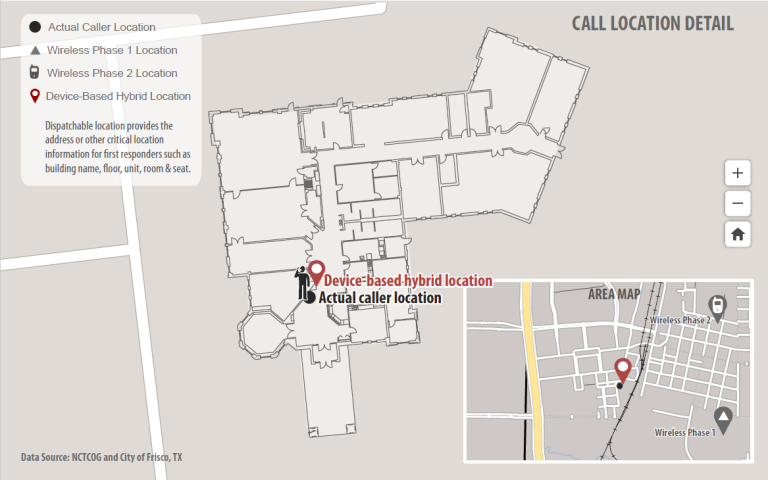
Vertical and Indoor 9-1-1 Location Mapping
Today more and more people rely on mobile phones as their primary phone service and are disconnecting wireline service altogether. As a result, more 9-1-1 calls are being placed from mobile phones than ever before, including from inside buildings where E9-1-1 mobile phone location technology does not work very well. Thanks to new FCC rules on this topic, wireless carriers and major industry technology players are now working to quickly address this issue.

RapidSOS and GeoComm Partner to Provide Accurate Location and Enhanced Data to 9-1-1 Centers using GeoComm Mapping Systems
GeoComm and RapidSOS are pleased to announce a strategic partnership to provide public safety agencies that use GeoComm 9-1-1 Public Safety Answering Point (PSAP) mapping systems with accurate location and additional data from the RapidSOS Clearinghouse. Through this partnership, PSAP’s working with GeoComm will be able to harness data from the RapidSOS NG911 Clearinghouse — including accurate handset location from all smartphone location sensors natively embedded into the 9-1-1 call flow.