Winchester, VA: 9-1-1 Team Relies on GeoComm Maps
Implementing new 9-1-1 mapping technology can be a large undertaking for public safety and GIS agencies, but experiencing improvements in 9-1-1 call processing capabilities and knowing that GeoComm Maps is reliable, makes the process worthwhile.
Improved
The City of Winchester Emergency Communication Center (ECC) in Virginia determined that they needed new 9-1-1 mapping software and sought out a solution that would provide peace-of-mind to the 9-1-1 caller, ECC staff, and emergency responders. They knew a fast, reliable 9-1-1 mapping system would be paramount when processing 9-1-1 calls to ensure emergency responders were properly guided to the location of the emergency. Winchester ECC officials chose GeoComm Maps to accomplish their objectives, and since its implementation, the city has noticed significant improvements in their 9-1-1 call processing capabilities.
Reliable
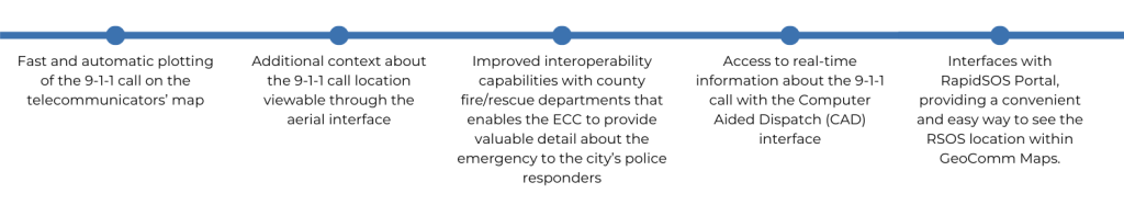
Some of the additional benefits Winchester ECC reports experiencing daily from GeoComm Maps includes:
“Since implementing GeoComm Maps, our telecommunicators know they can constantly rely on their 9-1-1 map. In fact, we’ve seen what a reliable resource it is that we’ve made it a requirement that the map be on the screen at each telecommunicator workstation for every 9-1-1 call,” said Erin Malloy, Director of Emergency Communications at City of Winchester, Virginia
Peace of Mind
Improving the 9-1-1 mapping technology at the City of Winchester ECC was a large undertaking, but they now have the peace-of-mind that 9-1-1 calls are processed quickly and accurately, proving that implementing GeoComm Maps made the process worthwhile.
“We also appreciate how easy it has been to get our GIS staff up-to-speed on the 9-1-1 mapping system,” Malloy stated. “It’s been a great working relationship between the ECC, GIS staff, and GeoComm teams.”


